Post by MoMo on Feb 28, 2014 18:41:07 GMT -6
The Early 2014 North American cold wave is an extreme weather event affecting parts of Canada and the United States east of the Rocky Mountains,. An Arctic cold front, initially associated with a nor'easter on January 2, tracked across Canada and the United States, resulting in heavy snowfall. Temperatures fell to unprecedented levels due to the front, and consequently low temperature records were broken across the U.S., leading to business, school, and road closures, as well as mass flight cancellations. Records of meteorological data have been kept by the National Weather Service since it was established in 1870. Altogether more than 200 million people were affected, in an area ranging from Rocky Mountains to the Atlantic Ocean and extending south to include roughly 187 million residents of the Continental United States.

Sudden stratospheric warming
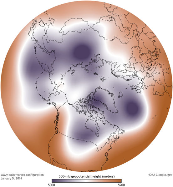
Beginning on January 2, the breakdown of the polar vortex and subsequent southward movement of tropospheric Arctic air was caused by sudden stratospheric warming (SSW), a phenomenon discovered in 1952. NASA states, "A major midwinter SSW event occurs when polar stratospheric temperatures increase by at least 25 K in one week, and the zonal-mean zonal wind at or near 10 hPa (at about 30 km altitude) reverses direction and becomes easterly north of 60° N."
Jet stream
An initial contrast formed between cold air in Canada and mild winter temperatures in the United States. The Met Office said the pressure difference caused significant winds where the air masses met, strengthening the jet stream, which went off-course and brought the cold air south. Winds led to bitter wind chills, worsening the impact of the record cold temperatures.
USA
On January 5, 2014, Green Bay, Wisconsin was −18 °F (−28 °C). The previous record low for this day was set in 1979.[13]
On January 6, 2014, Babbitt, Minnesota was the coldest place in the country at −37 °F (−38 °C). The cold air reached as far as Dallas, which experienced a low temperature of 16 °F (−9 °C).
The low temperature at O'Hare International Airport in Chicago was −16 °F (−27 °C) on January 6. The previous record low for this day was −14 °F (−26 °C), set in 1884 and tied in 1988. The National Weather Service adopted the Twitter hashtag #Chiberia (a portmanteau of Chicago and Siberia) for the cold wave coverage in Chicago and local media adopted the term as well. In spite of cold temperatures and stiff winds which exceeded the 23 mph wind and -23 air temperature when Chicago set its all-time wind chill record of −82 °F (−63 °C) in 1983, Chicago did not break the record because the NWS had adopted a new wind chill formula in 2001.
The average daily temperature for the United States on January 6 was calculated to be 17.9 °F (−7.8 °C). The last time the average for the country was below 18 was January 13, 1997; the 17-year gap was the longest on record.
On January 7, at least 49 record lows for the day were set across the country. On the night of January 6–7, Detroit hit a low temperature of −14 °F (−26 °C) breaking the records for both dates. The high temperature of −1 °F (−18 °C) on January 7 was only the sixth day in 140 years of records to have a subzero high. On January 7, 2014, the temperature in Central Park in New York City was 4 °F (−16 °C). The previous record low for the day was set in 1896, twenty-five years after records began to be collected by the government. Pittsburgh bottomed out at −9 °F (−23 °C), setting a new record low on January 6–7. Cleveland also set a record low on those dates at −11 °F (−24 °C). Temperatures in Atlanta fell to 6 °F (−14 °C), breaking the old record for January 7 of 10 °F (−12 °C) which was set in 1970. Temperatures fell to −6 °F (−21 °C) at Brasstown Bald, Georgia. Although the cold air moderated, the cold temperatures even reached subtropical Florida, where Tampa had a low of 34 °F (1 °C) in January 2014.
Canada
The coldest parts of Canada were the eastern prairie provinces, Ontario, Quebec, and the Northwest Territories. However, only Southern Ontario set temperature records.
During most of the cold wave, Winnipeg was the coldest major city in Canada. On January 6, it reached a low of −37 °C (−35 °F), while on January 7, the low was −36 °C (−33 °F). On both days, the temperature did not go above −25 °C (−13 °F). Other parts of southern Manitoba recorded lows of below −40 °C (−40 °F). On January 5, the daily high in Saskatoon was −28.4 °C (−19.1 °F) with a wind chill of −46 °C (−51 °F).
On January 7, 2014, a cold temperature record was set in Hamilton, Ontario: −24 °C (−11 °F);[26] London, Ontario was −25 °C (−13 °F)

February 11-17 Snow Storm
The February 11–17, 2014 North American winter storm was a snow and ice storm that affected the American South and East Coast of the United States.
The world's largest carrier Delta Airlines canceled over 2,000 flights,[4] and it was reported by 8:00 p.m. Thursday, February 13, that as many as 6,500 flights originating in or destined for the United States had been canceled. On that day 70 percent of flights were cancelled at airports in Baltimore, Philadelphia, Washington, D.C., and Charlotte.
As of February 14, 22 people had died from the storm.
Approximately 1.2 million homes and businesses lost power as the storm moved from the South through the Northeast. By the evening of Thursday, February 13, about 550,000 customers remained in the dark, mostly in South Carolina and Georgia.
More to come as this winter (hopefully winds down.)

Sudden stratospheric warming
Beginning on January 2, the breakdown of the polar vortex and subsequent southward movement of tropospheric Arctic air was caused by sudden stratospheric warming (SSW), a phenomenon discovered in 1952. NASA states, "A major midwinter SSW event occurs when polar stratospheric temperatures increase by at least 25 K in one week, and the zonal-mean zonal wind at or near 10 hPa (at about 30 km altitude) reverses direction and becomes easterly north of 60° N."
Jet stream
An initial contrast formed between cold air in Canada and mild winter temperatures in the United States. The Met Office said the pressure difference caused significant winds where the air masses met, strengthening the jet stream, which went off-course and brought the cold air south. Winds led to bitter wind chills, worsening the impact of the record cold temperatures.
USA
On January 5, 2014, Green Bay, Wisconsin was −18 °F (−28 °C). The previous record low for this day was set in 1979.[13]
On January 6, 2014, Babbitt, Minnesota was the coldest place in the country at −37 °F (−38 °C). The cold air reached as far as Dallas, which experienced a low temperature of 16 °F (−9 °C).
The low temperature at O'Hare International Airport in Chicago was −16 °F (−27 °C) on January 6. The previous record low for this day was −14 °F (−26 °C), set in 1884 and tied in 1988. The National Weather Service adopted the Twitter hashtag #Chiberia (a portmanteau of Chicago and Siberia) for the cold wave coverage in Chicago and local media adopted the term as well. In spite of cold temperatures and stiff winds which exceeded the 23 mph wind and -23 air temperature when Chicago set its all-time wind chill record of −82 °F (−63 °C) in 1983, Chicago did not break the record because the NWS had adopted a new wind chill formula in 2001.
The average daily temperature for the United States on January 6 was calculated to be 17.9 °F (−7.8 °C). The last time the average for the country was below 18 was January 13, 1997; the 17-year gap was the longest on record.
On January 7, at least 49 record lows for the day were set across the country. On the night of January 6–7, Detroit hit a low temperature of −14 °F (−26 °C) breaking the records for both dates. The high temperature of −1 °F (−18 °C) on January 7 was only the sixth day in 140 years of records to have a subzero high. On January 7, 2014, the temperature in Central Park in New York City was 4 °F (−16 °C). The previous record low for the day was set in 1896, twenty-five years after records began to be collected by the government. Pittsburgh bottomed out at −9 °F (−23 °C), setting a new record low on January 6–7. Cleveland also set a record low on those dates at −11 °F (−24 °C). Temperatures in Atlanta fell to 6 °F (−14 °C), breaking the old record for January 7 of 10 °F (−12 °C) which was set in 1970. Temperatures fell to −6 °F (−21 °C) at Brasstown Bald, Georgia. Although the cold air moderated, the cold temperatures even reached subtropical Florida, where Tampa had a low of 34 °F (1 °C) in January 2014.
Canada
The coldest parts of Canada were the eastern prairie provinces, Ontario, Quebec, and the Northwest Territories. However, only Southern Ontario set temperature records.
During most of the cold wave, Winnipeg was the coldest major city in Canada. On January 6, it reached a low of −37 °C (−35 °F), while on January 7, the low was −36 °C (−33 °F). On both days, the temperature did not go above −25 °C (−13 °F). Other parts of southern Manitoba recorded lows of below −40 °C (−40 °F). On January 5, the daily high in Saskatoon was −28.4 °C (−19.1 °F) with a wind chill of −46 °C (−51 °F).
On January 7, 2014, a cold temperature record was set in Hamilton, Ontario: −24 °C (−11 °F);[26] London, Ontario was −25 °C (−13 °F)

February 11-17 Snow Storm
The February 11–17, 2014 North American winter storm was a snow and ice storm that affected the American South and East Coast of the United States.
The world's largest carrier Delta Airlines canceled over 2,000 flights,[4] and it was reported by 8:00 p.m. Thursday, February 13, that as many as 6,500 flights originating in or destined for the United States had been canceled. On that day 70 percent of flights were cancelled at airports in Baltimore, Philadelphia, Washington, D.C., and Charlotte.
As of February 14, 22 people had died from the storm.
Approximately 1.2 million homes and businesses lost power as the storm moved from the South through the Northeast. By the evening of Thursday, February 13, about 550,000 customers remained in the dark, mostly in South Carolina and Georgia.
More to come as this winter (hopefully winds down.)


